Two rounds of showers and scattered thunderstorms are forecast to reach the Northeast, providing much-needed reprieve following a period of extreme heat.
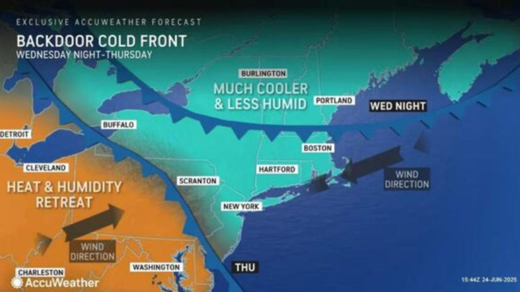
Forecasters predict that the first wave will form late Wednesday, June 25, followed by a second round on Thursday, June 26, as a powerful front moves across the region.
Both phenomena are predicted to flare up in the late afternoon and evening when atmospheric moisture increases and the heat dome that has trapped the eastern United States begins to dissipate.
The National Weather Service predicts that temperatures behind the system will plummet across the region.
Areas with highs in the triple digits earlier this week, such as New York, New Jersey, Pennsylvania, Connecticut, and Massachusetts, might experience readings in the 70s and 80s beginning Thursday.
Temperatures will moderate farther south, including in the District of Columbia, Maryland, and Virginia, beginning Friday.
Wednesday will be the last day of a heat wave that has brought blistering temperatures and humidity to much of the Northeast, with the exception of the extreme south.
In Boston, where temperatures flirted with 100 degrees on Tuesday, June 24, the cooling might be unusually abrupt. Highs may dip into the 60s on Thursday, June 26, and Friday, June 27, as cooler air moves in behind the storms.
The timing and intensity of each storm round may vary, but forecasters anticipate the most intense activity to coincide with elevated humidity levels along much of the I-95 corridor.
The forecast represents a significant change after a brief but intense burst of heat followed by weeks of damp, overcast weather.
While the sunny sky provided a change of pace, the rapidly rising temperatures left many wanting to chill down—and this week’s systems may finally deliver that balance.
“There’s even a rare backdoor cool front that will drop southward from New England to part of the mid-Atlantic region during the middle and latter part of this week,” AccuWeather Senior Meteorologist Brett Anderson said, “This can dramatically drop temperatures by 20-40 degrees in some cases, which is about as big as it gets this time of the year.”