The first snowfall of the season is always eagerly awaited by many but feared by others. It’s coming shortly in areas of Pennsylvania, regardless of where you stand. It’s not the snow so much as the chilly air that humbles us every fall as we prepare for another long Pennsylvania winter.
Windy weather will give way to a chilly end of the week, but Saturday will be an excellent day to get outside and enjoy the remnants of the pleasant portion of fall. By early next week, temperatures will plummet. We’re talking highs in the 30s and 40s, with brutal wind chills.
The first winter storm of the season could hit places to our north in Michigan and Ontario on Sunday, but it will be the strong northwest winds blowing over a very warm Lake Erie that bring us snow shortly after. The lake effect snow machine will awaken from its hibernation. By Monday morning, all current model advice indicates that snow will fall in sections of Western Pennsylvania, particularly the lake effect belts.
Snow showers caused by the lake effect are likely to continue through Monday and into early Tuesday, unless the currently forecasted low pressure alters course dramatically. As you can see below, forecasts predict moderate to heavy lake effect snow in Northwest Pennsylvania. As always, it will turn on and off as the streamers arrive.
Often, this early in the season, immediate lakefront areas like Erie and North East are warmer and have less snow. This won’t be the case, though, because of how severe the cold air intrusion is.
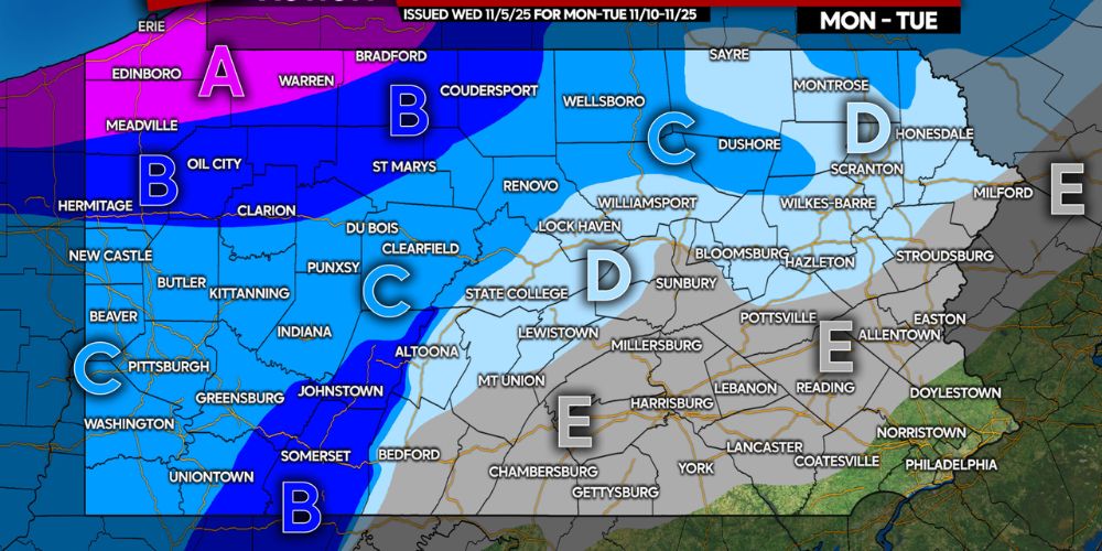
The chart below does not aim to show specific snowfall amounts this early in the season; instead, it is meant to give an idea of the potential for snowfall early next week.
Fall’s First Snowfall Potential In Parts Of Pa
Area A: Significant lake effect snowfall accumulation is possible Monday and Tuesday. Before the season begins, double-check your snow blowers and winter weather kit!
Area B: Light to moderate snowfall accumulation is possible Monday and Tuesday. Before using your snowblower, make sure it is in working order. Whether necessary or not, it is a beneficial concept!
Area C: The first snow showers of the season are expected, with modest snowfall accumulation possible.
Area D: The first snow showers of the season are likely, while substantial accumulation is doubtful.
Area E: The first snow showers of the season are expected.
We will have more updates in the coming days.