Meteorologists are tracking a developing storm system that could bring severe thunderstorms, destructive winds, and large hail to most of the southern United States this weekend.
According to meteorologist Chris Nunley, the severe weather threat will begin Saturday evening and last into the night, affecting states from northeast Texas to South Carolina. The main risks forecast are 60+ mph wind gusts and hail up to one inch in diameter, while isolated tornadoes cannot be completely ruled out.
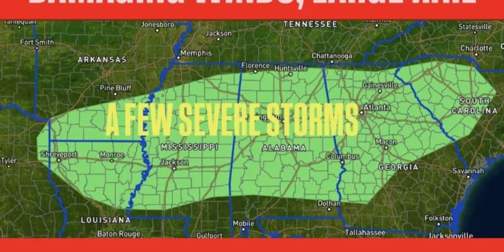
Forecast maps show a wide area of potential storm activity running from Shreveport, Louisiana, through Jackson, Mississippi, and Birmingham, Alabama, and eastward to Atlanta, Georgia, and Greenville, South Carolina.
Nunley explained that the warm Gulf moisture and a fast-moving cold front will produce ideal conditions for severe thunderstorm formation late Saturday.
“A few severe storms are possible Saturday evening into the overnight hours,” Nunley noted. “The main concerns are damaging wind and hail, though a brief tornado cannot be ruled out.”
Evening and Overnight Timing Raises Safety Concerns
This Article Includes
Because many storms are likely to start and intensify after sunset, meteorologists recommend that homeowners have numerous ways to receive weather notifications, particularly during sleeping hours.
Strong wind gusts could cause:
- Downed tree limbs and power lines
- Scattered power outages
- Localized property damage
Meanwhile, huge hail could cause damage to vehicles, rooftops, and crops in regions of Mississippi and Alabama, where instability is expected to be highest.
Forecast Breakdown by Region
- Texas and Louisiana: Initial storms are likely to develop by Saturday afternoon, bringing heavy rain and lightning before pushing eastward.
- Mississippi and Alabama: Stronger, more organized storm clusters are expected Saturday night, posing the greatest wind and hail threat.
- Georgia and South Carolina: The line of storms could reach these areas by early Sunday morning, with diminishing but still notable intensity.
What Residents Should Do
Meteorologists emphasize the value of staying weather-aware throughout the weekend. Residents of the risk zone should:
- Secure outdoor items such as furniture or decorations that could blow away.
- Charge devices in case of power loss.
- Park vehicles in garages or under cover to avoid hail damage.
- Review severe weather safety plans, especially for families with children or pets.