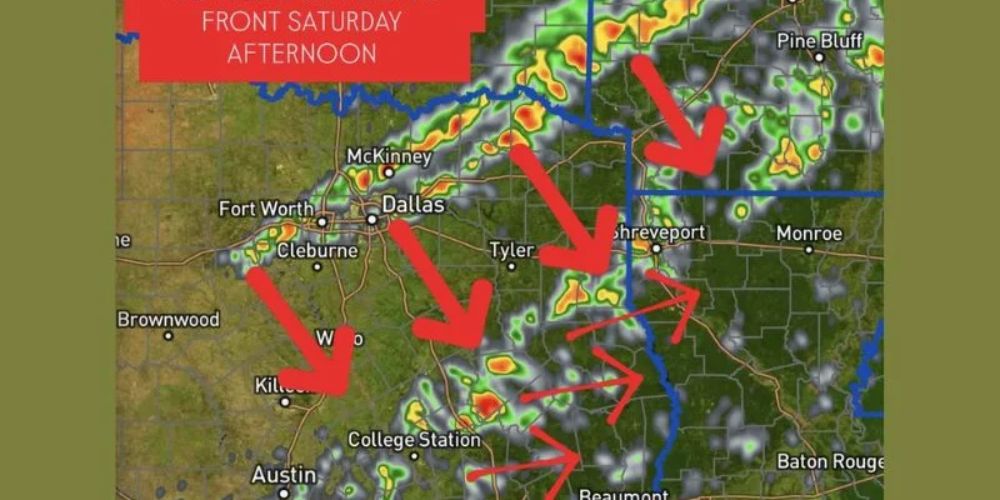
A rush of Arctic air moving south will collide with warmer Gulf moisture on Saturday, causing strong to severe thunderstorms across Texas, southeastern Oklahoma, Arkansas, and Louisiana. Forecast models predict heavy rain, gusty winds, and isolated severe storms by Saturday afternoon and evening, especially from central Texas to east Texas and into Louisiana.
Meteorologists warn that the storm line might worsen as it advances east, forming ahead of the advancing cold front and causing disruptions across numerous states throughout the Thanksgiving weekend travel period.
Showers and storms are expected to develop along and out ahead of the coming Arctic cold front starting Saturday afternoon. The most powerful storms are forecast to move from Austin and College Station to Dallas, Tyler, and Shreveport, eventually moving east into Arkansas and Louisiana by evening.
As the front passes through, Fort Worth, Waco, and Beaumont are also likely to see clusters of thunderstorms, which could result in lightning, heavy rainfall, and severe wind gusts.
Forecasters advise locals to monitor changing weather conditions throughout the day, as the collision of cold and warm air masses could lead to the swift formation of storms.
While widespread severe weather is unlikely, forecasters warn that isolated storms may become severe, particularly in eastern Texas and western Louisiana, where warmer, more humid air will feed instability.
Localized flooding is also conceivable in areas where rain falls often. Drivers heading to post-Thanksgiving events are advised to exercise caution on highways and interstates, particularly when heavy rains restrict visibility.
Stronger storm cells emerging along the boundary do not rule out the possibility of localized destructive gusts and brief tornado-like rotations.
Temperatures are predicted to fall behind the front, with cold, dry air rushing through the region by late Saturday night. Temperatures in cities such as Dallas, Austin, and Houston could plummet by 20-25°F within hours of the frontal passage.
The arrival of the Arctic air mass will cause a substantial pattern shift in the southern United States, as it quickly transitions from mild, humid weather to winter-like temperatures.
Forecasters urge staying up-to-date with local alerts and monitoring weather radios or mobile notifications as the front approaches. Travel delays are possible as a result of the heavy rain and strong winds.
Residents in the affected areas, particularly central and eastern Texas and Louisiana, are encouraged to stay weather-aware through Saturday afternoon and evening as circumstances change.
