Snowfall forecasts for an upcoming quick-moving system have escalated, with additional snow expected overnight into Tuesday, Dec. 23, potentially causing a chaotic morning commute throughout the tristate, according to the National Weather Service.
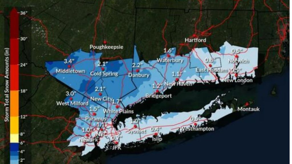
The most recent forecast, issued late Monday afternoon, Dec. 22, currently predicts totals ranging from 1 to 3 inches across the Lower Hudson Valley, northeastern New Jersey, and southwestern Connecticut, with higher amounts possible in isolated regions.
Coastal areas, including New York City, Long Island, and coastal Connecticut, are forecast to receive up to 1 inch of snow before transitioning to rain by midday Tuesday.
Interior areas north and west of the city, where cooler temperatures will stay longer, could see accumulations of 2 to 3 inches, with higher elevations topping 3 inches, such as at Middletown in Orange County, New York, where totals could reach 3.4 inches.
A Winter Weather Advisory has been issued for portions of the region, including Orange, Putnam, Rockland, and Northern Westchester counties in New York, as well as Passaic and western Bergen counties in New Jersey and northern Fairfield County in Connecticut. The advisory is in effect Tuesday from 4 a.m. to 4 p.m.
The National Weather Service cautions that untreated roadways may turn snow-covered and slippery during the Tuesday morning commute.
“A faster transition from snow to rain will reduce snowfall accumulations,” the agency stated in a forecast update. “A slower changeover will increase snowfall totals.”
According to AccuWeather, locations farther inland and higher in the tristate have the highest chance of receiving 3 inches or more of snow before any mix or rain hits. Rain is predicted to dominate the I-95 corridor by lunchtime Tuesday, keeping accumulations low.
The storm is forecast to pass by Tuesday evening, and seasonal temperatures and dry weather will return for Christmas Eve.