A big snowstorm is expected to hit much of New Jersey and Pennsylvania from west to east on Friday and Saturday.
While a high-pressure system over eastern Canada keeps the Northeast chilly and New England dry, a low-pressure system will move quickly from the Great Lakes to the Mid-Atlantic. An area of snow will form over central Michigan, western Pennsylvania, and New York early Friday and move south and east, delivering snow to the rest of Pennsylvania and New Jersey from west to east Friday afternoon and night. The majority of the snowfall that has been building in Pennsylvania and New Jersey should finish early Saturday morning, but it will continue in central and southern New England until afternoon. All precipitation associated with this cyclone should leave the coast by Saturday evening.
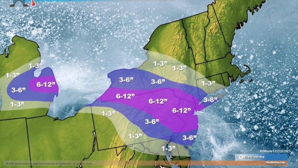
While northern and central Pennsylvania and New Jersey are likely to receive the most snow, a change in the arrangement of the cold air mass in front of the storm, as well as the system’s severity, would have a substantial impact on precipitation amounts and types.
Plain rain will fall on the system’s south side, most likely in West Virginia, much of Maryland, all of Virginia, and extreme southern Delaware. Between this rain area and the snow region to the north, an icy mix of sleet and freezing rain is forecast, with the chance of ice building.
Up to 6 inches of snow are expected in Philadelphia and New York City, as well as surrounding locations. This system is forecast to bring little or no snow to central and northern upstate New York, Vermont, New Hampshire, and Maine, as well as lighter amounts to sections of western Connecticut and Massachusetts.
Rain or a wintry mix will keep quantities lower on the south side of the system; roughly 3 inches is forecast in southern New Jersey and northern Delaware, with much smaller amounts south of that. A little dusting of snow may fall in Washington, DC, and Baltimore, but the majority of the snowfall should occur higher up the I-95 corridor, toward Philadelphia and New York.
It is too early for the National Weather Service to issue watches or warnings for this storm; this will most likely happen late Christmas Eve or early Christmas Day before the storm arrives.