
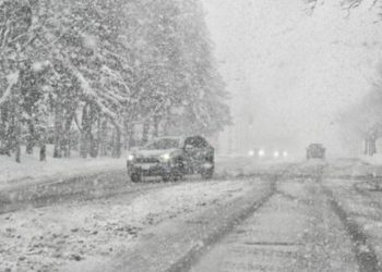
A widespread Winter Weather Advisory continues in force until 7 a.m. Tuesday in parts of West Virginia, southwest Virginia, and western North Carolina, where snow and strong winds are predicted to create hazardous travel conditions through the beginning of the week.
According to the National Weather Service offices in Charleston and Greenville-Spartanburg, total snow accumulations will be 2 to 4 inches in most lower elevations, 4 to 6 inches above 3,500 feet, and up to 10 inches locally around the Tennessee border and highest ridges.
Related posts


Advisories are in effect in Kanawha, Boone, Logan, Webster, Randolph, and Upshur Counties in West Virginia, Dickenson and Buchanan Counties in Virginia, and Avery, Madison, Yancey, Mitchell, Haywood, and Graham Counties in North Carolina.
Forecasters predict severe winds of up to 45 mph, which might bring down tree branches and electrical lines, resulting in isolated outages. The snow is predicted to make many mountain roads treacherous and inaccessible, especially during Monday morning and evening commutes.
Motorists are advised to slow down and use caution while storing emergency supplies in their vehicles. Residents should keep an eye on 511 traffic updates and local weather alerts for any changes until Monday night.


