Forecasters predict that a multi-day heavy rain event will hit Texas, Louisiana, Mississippi, and parts of the Southeast beginning Monday, November 18, as a strong weather system moves across the Southern Plains and into the Gulf states.
According to the most recent projections, areas in eastern Texas, southern Arkansas, northern Louisiana, and central Mississippi face a minor to moderate risk of receiving more than one inch of rain within 24 hours, increasing concerns about localized flooding and travel disruptions.
Related posts


Timing and Risk Areas
Meteorologists with national weather forecasts predict that the strongest rainfall will fall between November 19 and 20, with precipitation continuing across sections of the region until Friday, November 22.
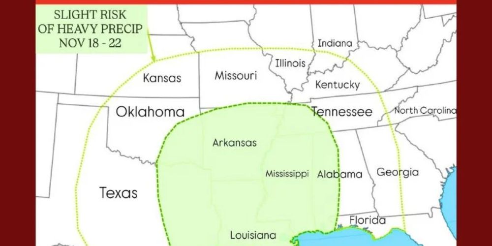
- Slight Risk (Nov 18–22): Covers most of Texas, Oklahoma, Arkansas, and Louisiana.
- Moderate Risk (Nov 19–20): Focused over Louisiana, Mississippi, and parts of southern Alabama and the Florida Panhandle.
Rainfall totals may surpass 2-3 inches in some places, particularly near the Gulf Coast, where moisture from the Gulf of Mexico is likely to increase storm strength.
“We’re looking at a classic late-autumn setup,” one meteorologist said. “Moisture from the Gulf will meet colder air from the Plains, creating a zone of persistent, heavy rainfall. Flash flooding will be possible in low-lying and urban areas.”
Potential Flooding and Travel Impacts
Forecasters warn that rainfall rates may be high enough to produce minor flooding along creeks, rivers, and roads. During peak rain times, urban hubs such as Houston, Jackson, and Little Rock may face road ponding and slower commutes.
Rural areas, particularly those with clay soils or poor drainage, are at risk of short-term runoff flooding. Emergency management officials in affected states are encouraging residents to check drainage systems, avoid flooded roads, and pay attention to local forecasts.
Weather Pattern Driving the System
An upper-level trough traveling over the western United States will drag Gulf moisture northward into the Southern Plains, triggering the rainstorm. As the system intensifies, it is forecast to bring extensive cloud cover, thunderstorm activity, and lower temperatures to most of the South.
While the rain will provide much-needed rainfall to drought-stricken areas of Texas and Oklahoma, meteorologists warn that the event’s intensity and duration may result in localized floods, particularly where soils are already saturated from previous rains.
Looking Ahead
After the system exits late next week, cooler and drier air is expected to move in behind it, providing a little respite before another potential storm system comes near Thanksgiving week.
Residents in Texas, Louisiana, Mississippi, Alabama, and neighboring states are recommended to monitor revised forecasts and local cautions as the system develops.


