
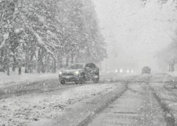
Heavy lake-effect snow and damaging winds may hit sections of northwestern Pennsylvania on Monday afternoon, as a Winter Storm Watch stays in effect until Wednesday morning.
According to the National Weather Service in Cleveland, Crawford County and southern Erie County could see 6 to 12 inches of snow, with snowfall rates reaching 1 inch per hour during the heaviest periods. Wind gusts might approach 60 mph, resulting in widespread blowing and drifting snow.
Related posts


The watch area includes Meadville, Titusville, Corry, Union City, and Edinboro. The greatest snowfall is forecast from late Monday afternoon through Tuesday, when traffic conditions may swiftly worsen.
Forecasters warn that falling and blowing snow could reduce visibility to less than a quarter mile at times. Travel might become difficult or dangerous, especially during the Monday evening and Tuesday morning commutes. Strong winds may also cause tree damage and sporadic power outages.
The National Weather Service recommends citizens regularly monitor prediction updates, as watches may be escalated to warnings when confidence grows. People might contemplate postponing non-essential travel, especially during periods of high snowfall.
Those who must travel are advised to drive with great caution and to carry a safety kit for winter storms that includes tire chains, blankets, additional clothing, water, a flashlight, and emergency supplies in case they become trapped.
Commuters, students, and workers in northwest Pennsylvania may face dangerous road conditions and schedule interruptions through midweek due to the multi-day storm warning.
Additional updates will be provided as the storm system progresses and confidence in snowfall totals and impacts grows.


