
Strong to severe thunderstorms are predicted to move across West Central Texas Sunday night, posing a risk of large hail and damaging winds between 8 p.m. and 7 a.m. Monday. The most serious concerns are centered on Abilene, San Angelo, and cities north and east, with hazards expected to disrupt overnight travel and early morning commutes.
According to the National Weather Service in San Angelo, storms will form north of the region this afternoon and then push south and east through the evening and overnight. The primary concerns include hail reaching the size of golf balls and wind gusts exceeding 60 mph. A few storms may also spawn isolated tornadoes, particularly in rural areas north of Interstate 20.
Related posts
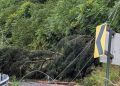

Cities around Highway 277 and US 83, such as Stamford, Sweetwater, and Ballinger, may see the most severe storms late Sunday night. Residents are advised to secure unsecured outdoor objects, avoid unnecessary travel during the storm, and charge cell phones in the event of power shortages. TxDOT and emergency services are vigilant for fallen trees and electrical lines, especially in areas predicted to experience the strongest storms.
Severe weather dangers will persist until Monday morning, with further updates possible if the situation develops. Residents should keep NOAA weather radios and alerts turned on at nighttime, as warnings may occur with little notice.


