Fall is taking its time cooling down Texas, as it always does. Typically, cold weather does not arrive in the Lone Star State until late October or November. However, a cold front crossing the northern part of the state will cause a 10-degree decrease in temperatures in some major cities, as well as stormy weather across much of Texas.
The National Weather Service (NWS) and other reliable forecasters are certain that a weak La Niña would result in milder and drier cold weather seasons (autumn and winter). However, this weather trend can result in cooler jet streams out of the Northeast, and long-range weather forecasters foresee several unseasonably cold days this fall.
Related posts
This Article Includes
- 0.1 Related posts
- 0.2 U.S. Issues Warning For 4 states preparing for 60-80 MPH winds tonight
- 0.3 Dangerous Storm System Brings 70 MPH Gusts, Possible Tornadoes Tonight
- 1 Texas Panhandle to see 10-degree dip in afternoon temps amid cold front
- 2 North Texas, Dallas-Fort Worth see storm odds rise amid cold front
- 3 Cold front brings storm chances to Central Texas


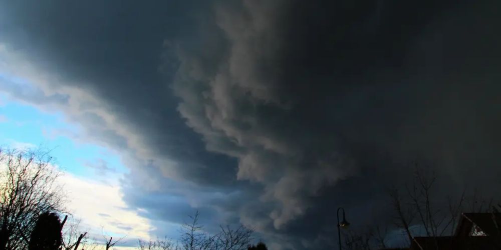
According to the current NWS forecast, a cold front will barely pass over the Texas Panhandle this week, beginning Tuesday night, bringing cooler days and rainy weather to several locations.
Texas Panhandle to see 10-degree dip in afternoon temps amid cold front
The northernmost part of the Texas Panhandle has the most severe winter weather. It’s where snowfall is relatively common, far more so than the rest of the state. While snow is not in the forecast, the dramatic weather trend will continue when a cold front arrives midweek.
Between Tuesday afternoon, September 16, and the following Thursday afternoon, high temperatures will fall from 86 degrees to 74 degrees. That’s a staggering 12-degree difference that gradually fades over 48 hours. Storms are more likely with this temperature change.
“A cold front should travel over the region on Wednesday and early Thursday morning.” This will result in cooler temperatures on Thursday as rain chances remain for the Texas and Oklahoma Panhandles,” the National Weather Service adds in its long-term prediction discussion.
Between Tuesday night and Thursday night, there is a 20% to 60% chance of rain and thunderstorms, with the highest likelihood occurring on Wednesday evening.
Even places further in will experience a significant drop as the cold front continues to march south. Amarillo’s temperature is expected to drop by 6 degrees between Monday afternoon and the hottest time of day on Friday, from 87 to 81. Evenings will seem almost chilly in the second part of the week, with temperatures in the mid-50s on Wednesday and Friday. In fact, overnight lows will fall below 60 until the beginning of next week.
In fact, these towns will suffer thunderstorms ranging from 20% to 70% from Tuesday night to Friday night.
North Texas, Dallas-Fort Worth see storm odds rise amid cold front
The sweeping cold front forecast in the Panhandle and several West Texas communities may not be as severe in North Texas. In the Dallas-Fort Worth Metroplex, the frigid air will largely bring thunderstorms.
The National Weather Service DFW office predicts a 20% to 40% probability of thunderstorms beginning Wednesday night and continuing into the beginning of next week. However, there will be a slight chill as afternoons peak at 90 degrees all weekend—a welcome respite after the heat of July when temperatures reached almost 100—and evenings will remain in the mid-70s.
Cold front brings storm chances to Central Texas
Unfortunately, fall has yet to reach Central Texas. Major metropolitan centers, such as Austin and San Antonio further south, may not even notice the cold front approaching. However, some low-level thunderstorm probabilities (20%) remain over the region for the majority of the weekend.
“Temperatures will remain above normal for mid to late September, in the mid 90s. There is still no sign of our first true Fall cold front, so for the foreseeable future, expected warmer than normal temperatures,” the NWS long-term forecast reads for the area.
However, don’t rule out an early temperature dip just yet. According to the Farmers’ Almanac, the last week of September should be “unseasonably chilly” in the region. So, perhaps September will feel like fall in Texas this year, even in Central Texas.


