We have issued First Alert Weather Days for Friday and Saturday due to elevated rain chances in Arizona.
Prior to that, we will have another warm day on Thursday with a high of 106 before experiencing a significant temperature drop. We’re down to highs of around 92 degrees on Friday and 88 degrees on Saturday! The average temperature during this time of year is 98 degrees.
Related posts

The risk of showers and storms begins Thursday afternoon, with the biggest possibilities remaining for Friday and Saturday. Severe storms can produce heavy rains and cause flash flooding. Some areas of the state are under a flood watch, which began on Thursday.
The watch will go into effect in eastern Arizona on Thursday, covering Tucson, Safford, and Willcox, and will last until 8 p.m. Saturday.
The watch will take effect Friday AM in eastern Maricopa County and sections of Pinal County, including Fountain Hills, Apache Junction, Casa Grande, and Maricopa. That is expected to end at 11 p.m. on Friday.
These changes are due to a closed low-pressure system spinning off the coast of California. As it moves onshore and eastward, the increasing moisture will bring showers and thunderstorms beginning Thursday. Thursday’s activity appears to be heavily dependent on outflow boundaries from distant thunderstorms.
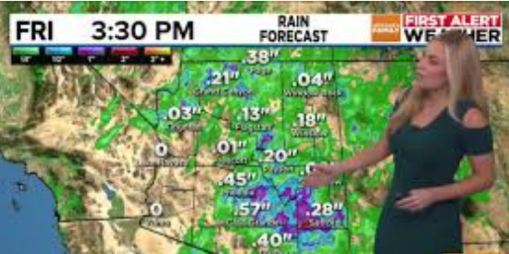
Models continue to be uncertain about how much rain the Valley will receive by Friday and Saturday. Some projections predict over half an inch in Phoenix, with even more in the southeast.
The forecast might have a significant impact on high school football games, as well as ASU’s game versus TCU at 6 p.m. on Friday. Heavy rain, high winds, and lightning are all possible on Friday.
As this system weakens, we are still tracking storm chances through Saturday, and depending on how long it stalls over the region, rain may linger until Sunday morning.


