
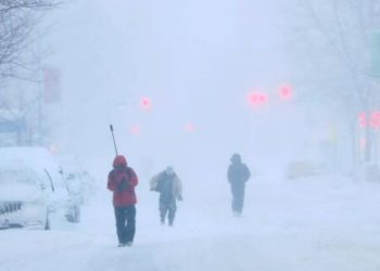
Northern Wisconsin’s quiet, mild start to November is coming to an abrupt end, with a considerably colder and snowier pattern developing between November 9 and 15. Forecasters warn that a series of cold fronts may bring heavy snow to the Northwoods, likely marking the season’s first widespread snowfall.
According to the NOAA Climate Prediction Center, northern Wisconsin will experience below-average temperatures and above-average precipitation through mid-month, favoring lake-effect and system snow in Iron, Vilas, Oneida, Marathon, and Bayfield counties. The first front is forecast to arrive early next week, bringing Arctic air and severe northwest winds from Lake Superior, resulting in many rounds of snowfall.
Related posts

According to the National Weather Service offices in Green Bay and Duluth, some higher terrain locations could receive several inches of snow, with lesser accumulations south of Wausau and Stevens Point. High temperatures will drop into the 30s, and overnight lows will likely fall into the 20s, with wind chills in the teens in the early morning hours.
Prepare for slick sections, blowing snow, and reduced visibility in thicker bands on Highway 51, U.S. 2, and Interstate 39. The Wisconsin Department of Transportation advises caution during the early season and reminds drivers to check road conditions before driving north.
Residents are warned to winterize their homes, secure their pipelines, and stock up on emergency supplies before the temperatures drop even further. With Thanksgiving coming, this cold surge indicates that the Upper Midwest is entering a snowier, more wintry phase, with northern Wisconsin likely at the center of it.


