Thursday, April 30, 2026
  • Terms and conditions
  • Disclaimer
  • DMCA Policy
  • Cookie Policy
RHS News
  • U.S. News
  • Washington News
    • Kennewick News
    • Seattle News
    • Spokane News
    • Tacoma News
    • Vancouver News
    • Yakima News
  • Politics
  • Sports
  • Weather
  • Finance
  • Contact Us
No Result
View All Result
RHS News
Home Weather

Cleveland–Pittsburgh Corridor to Receive 3–12″ of Lake-Effect Snow Through Monday

by Paige Wuthrich
November 17, 2025
in Weather
Cleveland–Pittsburgh Corridor to Receive 3–12″ of Lake-Effect Snow Through Monday

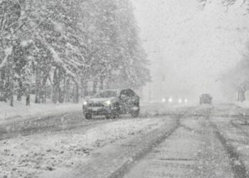
A growing lake-effect snow event is predicted to affect eastern Ohio and western Pennsylvania from Sunday afternoon to Monday, with snowfall totals varying depending on the exact location of the dominating snow band. Cold northwest flow over Lakes Erie and Ontario will provide narrow but strong snowfall pathways that might cause dangerous travel, particularly north of Interstate 80.

Forecasters at the National Weather Service in Cleveland predict 3 to 6 inches of snow in the higher terrain of eastern Erie and Crawford Counties in Pennsylvania by early Monday morning. Additional light accumulations of 1 to 2 inches may occur on Monday as lingering bands reactivate. Locally, higher totals are conceivable where the major band sets up for several hours.

Related posts

This Article Includes

  • 1 Related posts
  • 2 Winter Storm Watch Issued as 14 Inches of Snow Threaten ‘Very Dangerous’ Travel
  • 3 3 U.S. College Students Tragically Discovered Dead Off-Campus
Winter Storm Watch Issued as 14 Inches of Snow Threaten ‘Very Dangerous’ Travel

Winter Storm Watch Issued as 14 Inches of Snow Threaten ‘Very Dangerous’ Travel

April 30, 2026
3 U.S. College Students Tragically Discovered Dead Off-Campus

3 U.S. College Students Tragically Discovered Dead Off-Campus

April 29, 2026

Meanwhile, the National Weather Service in Pittsburgh advises that regions north of Interstate 80 may experience much higher totals, particularly in the most persistent part of the lake-effect band. Snow accumulations of up to 12 inches are anticipated where the band remains stationary tonight until Monday morning. However, a minor movement of a few miles might spell the difference between a foot of snow, a few inches, or even flurries. This high gradient is typical of lake-effect events, but it creates uncertainty for local people.

The worst snowfall is forecast between nightfall Sunday and Monday morning, coinciding with peak commuter hours in certain places. The core of the band will most likely have reduced visibility, snow-covered secondary roads, and hazardous travel conditions.

Travelers in eastern Ohio and western Pennsylvania, particularly those planning trips north of I-80, should pay close attention to forecast changes. Even short-distance driving may face quickly changing weather conditions, including near-whiteouts at times. Forecasters warn that circumstances may change rapidly as the lake-effect band reorganizes into Monday.

ShareTweetPin
Previous Post

Michigan Winter Weather Alert: Lake-Effect Snowfall to Build to 3–6″ Through Monday

Next Post

Winter Storm Warning: 16 Inches Of Snow To Hit Northeast

Paige Wuthrich

Paige Wuthrich

Related Posts

Winter Storm Watch Issued as 14 Inches of Snow Threaten ‘Very Dangerous’ Travel
Weather

Winter Storm Watch Issued as 14 Inches of Snow Threaten ‘Very Dangerous’ Travel

April 30, 2026
3 U.S. College Students Tragically Discovered Dead Off-Campus
Weather

3 U.S. College Students Tragically Discovered Dead Off-Campus

April 29, 2026
U.S. Issues ‘Warning’ For Three States As 80 MPH Winds Approach
Weather

U.S. Issues ‘Warning’ For Three States As 80 MPH Winds Approach

April 27, 2026
Four U.S. States Warned About Thunderstorm With 70 MPH Wind Tonight
Weather

Four U.S. States Warned About Thunderstorm With 70 MPH Wind Tonight

April 25, 2026
Winter Storm Warning Issued After Nearly 5 Feet of Snow
Weather

Winter Storm Warning Issued After Nearly 5 Feet of Snow

April 25, 2026
Portions of California & Nevada prepare for up to 18 inches of snow and 90 mph winds
Weather

Portions of California & Nevada prepare for up to 18 inches of snow and 90 mph winds

April 21, 2026
Next Post
Winter Storm Warning: 16 Inches Of Snow To Hit Northeast

Winter Storm Warning: 16 Inches Of Snow To Hit Northeast

Leave a Reply Cancel reply

Your email address will not be published. Required fields are marked *

BROWSE BY CATEGORIES

  • Accident
  • Crime
  • Finance
  • Kennewick News
  • Missing Person
  • Politics
  • Tacoma News
  • U.S. News
  • Washington News
  • Weather

Recent News

  • Chicago men arrested with drugs and mushrooms, guns in Evanston: police
  • 4 teens assault 12-year-old outside Columbus library as he waited to be picked up
  • 9 people arrested and $1.13M cash, 40 kgs of cocaine seized in Puerto Rico to Florida mail pipeline
  • Former Missouri trooper sentenced to prison for unlawful phone searches
  • Couple Sentenced To Prison For Fentanyl Trafficking Scheme In Central Florida

Category

  • Accident
  • Crime
  • Finance
  • Kennewick News
  • Missing Person
  • Politics
  • Tacoma News
  • U.S. News
  • Washington News
  • Weather

Important Pages

  • About Us
  • Contact Us
  • Cookie Policy
  • Disclaimer
  • DMCA Policy
  • Editorial Policy
  • Fact-Checking Policy
  • Privacy Policy
  • Terms and conditions
No Result
View All Result
  • U.S. News
  • Washington News
    • Kennewick News
    • Seattle News
    • Spokane News
    • Tacoma News
    • Vancouver News
    • Yakima News
  • Politics
  • Sports
  • Weather
  • Finance
  • Contact Us

© 2025 RhsNews.Co

Go to mobile version