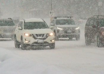
The National Weather Service (NWS) has issued a new Winter Weather Advisory for sections of southeast Minnesota and western Wisconsin, where snow may accumulate quickly overnight and produce hazardous driving conditions for the Tuesday morning commute.
The NWS Twin Cities office predicts showers in southern Minnesota early Monday evening, followed by a rain-snow mix overnight. Forecasters predict that a narrow, rapidly deepening zone of heavy snow will form from Canby and Redwood Falls through the southern Twin Cities metro and eastward into areas immediately south of Eau Claire.
The current caution, which covers Goodhue County in Minnesota and Eau Claire, Pepin, and Pierce counties in Wisconsin, is in effect from 1 a.m. until 11 a.m. on Tuesday. This notice includes the following cities: Red Wing, River Falls, Durand, and Eau Claire.
Forecasters predict up to 3 inches of snow, with higher accumulation in certain regions. Rain and snow may mix at times, but surface temperatures near freezing will determine how much accumulates. According to the NWS, even a one-degree temperature difference can modify where the heaviest snowfall occurs.
Roads are anticipated to turn slick in the early morning hours, with the most substantial effects expected during the Tuesday morning commute in southeast Minnesota and western Wisconsin. Heavy snowfalls may also restrict visibility.
Officials warn drivers to slow down, allow extra travel time, and monitor current road conditions. Minnesota residents should check 511mn.org, while Wisconsin visitors should go to 511wi.gov for the most recent information.
Meteorologists may make more forecast modifications tonight as they monitor the limited snow band’s development.

