Monday, March 16, 2026
  • Terms and conditions
  • Disclaimer
  • DMCA Policy
  • Cookie Policy
RHS News
  • U.S. News
  • Washington News
    • Kennewick News
    • Seattle News
    • Spokane News
    • Tacoma News
    • Vancouver News
    • Yakima News
  • Politics
  • Sports
  • Weather
  • Finance
  • Contact Us
No Result
View All Result
RHS News
Home Weather

Pennsylvania, New York, New Jersey, Maryland, And New England Brace For Snow And Ice As Amplified Clipper System Targets December 26–27

by Paige Wuthrich
December 24, 2025
in Weather
Pennsylvania, New York, New Jersey, Maryland, And New England Brace For Snow And Ice As Amplified Clipper System Targets December 26–27

A growing winter weather system is causing concern in the Northeast and Mid-Atlantic United States, as forecast data indicates a more powerful clipper storm capable of dumping snow, sleet, and pockets of ice from Friday to early Saturday, December 26-27.

While a weaker clipper will pass through the region ahead of this system, meteorologists believe Friday’s setup has a bigger impact potential, particularly in inland and northern areas where colder air is more firmly in place.

Related posts

This Article Includes

    • 0.1 Related posts
    • 0.2 Dangerous Winter Storm Expected Across 9 Counties in New York
    • 0.3 Maryland & Pennsylvania Weather Alert: Tornado Threat and 70 MPH Winds From Harrisburg to Baltimore Monday Evening
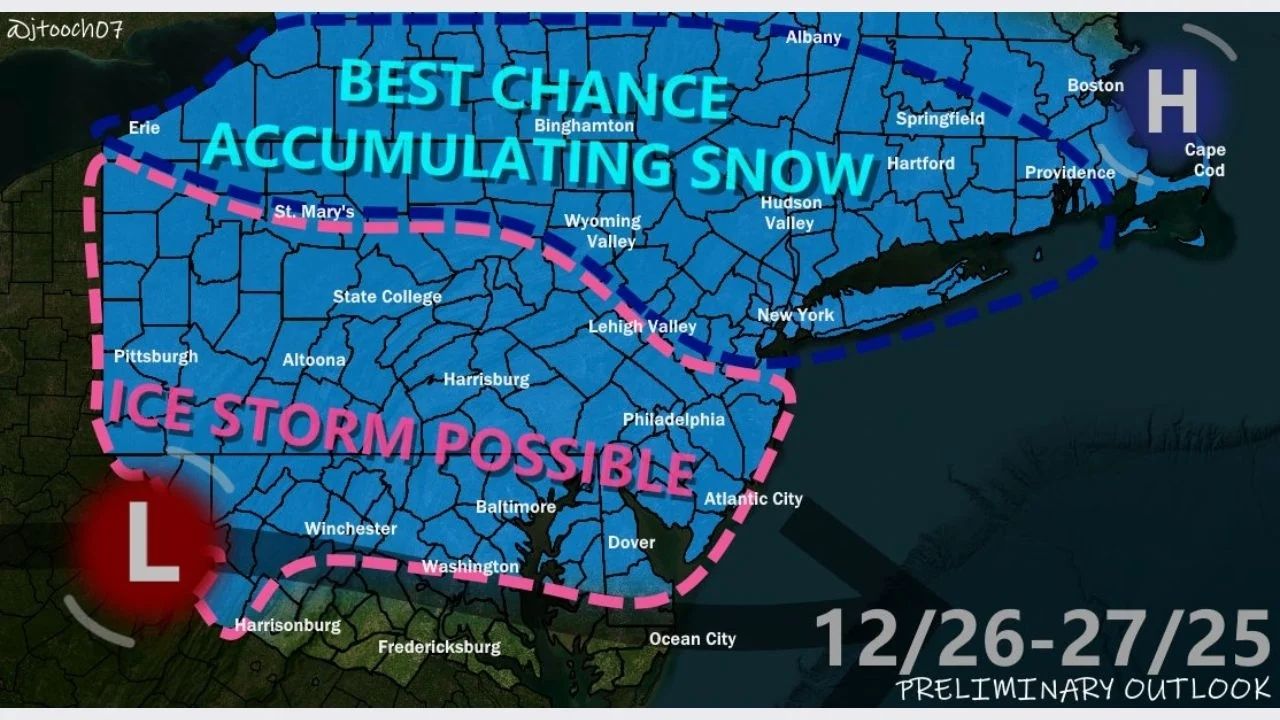
  • 1 Best Chance for Accumulating Snow in Northern and Interior Zones
  • 2 Ice Storm Risk Increases Across the Mid-Atlantic Interior
  • 3 Major Cities Face Mixed Impacts and Travel Disruptions
  • 4 Temperature Contrast Drives Sharp Impact Differences
  • 5 Forecast Confidence Still Evolving
Dangerous Winter Storm Expected Across 9 Counties in New York

Dangerous Winter Storm Expected Across 9 Counties in New York

March 16, 2026
Maryland & Pennsylvania Weather Alert: Tornado Threat and 70 MPH Winds From Harrisburg to Baltimore Monday Evening

Maryland & Pennsylvania Weather Alert: Tornado Threat and 70 MPH Winds From Harrisburg to Baltimore Monday Evening

March 16, 2026

Best Chance for Accumulating Snow in Northern and Interior Zones

The most likely areas for snow accumulation, according to forecasts, include central and northern Pennsylvania, upstate New York, interior New England, and mountainous terrain in the Northeast.

These places are on the colder edge of the system, with temperatures forecast to hover around or below freezing for much of the event, allowing snow to pile more efficiently. Snowfall potential increases north and west of major metropolitan areas when colder air remains trapped for longer.

Ice Storm Risk Increases Across the Mid-Atlantic Interior

Further south and west, forecast models predict a significant ice storm risk in southern Pennsylvania, northern Maryland, and inland regions of the Mid-Atlantic.

In certain places, a warm layer aloft mixed with sub-freezing surface temperatures may promote freezing rain or sleet, especially overnight and early in the morning. Even little ice accumulations can provide hazardous traffic conditions, particularly on untreated roadways and elevated surfaces.

Major Cities Face Mixed Impacts and Travel Disruptions

Urban corridors from Philadelphia northward through New York City and into southern New England are expected to receive mixed precipitation, with snowfall turning to sleet or rain depending on timing and temperature.

Forecast projections suggest:

  • Under 1 inch of snow near Philadelphia
  • 1 to 3 inches closer to New York City and Boston
  • Higher totals north and west of these cities

While totals may be low in city centers, slushy buildup and brief ice could hinder morning and evening travel, especially along heavily frequented routes like Interstate 95.

Temperature Contrast Drives Sharp Impact Differences

One of the distinguishing features of this system is the tight temperature gradient across the region:

  • Above-freezing conditions are expected across parts of central Maryland and coastal zones
  • Near-freezing temperatures persist across southern Pennsylvania
  • Below-freezing air dominates the Poconos, Lehigh Valley, interior New York, and New England

This contrast allows for fast changes in precipitation type, resulting in highly varying localized impacts over short distances.

Forecast Confidence Still Evolving

Meteorologists advise that this is only a preliminary forecast, with the exact storm course, thermal profiles, and precipitation amounts all susceptible to change. Small changes in the system’s route could substantially modify where snow, ice, or rain fall.

Residents in the impacted areas are encouraged to keep an eye on revised predictions, particularly those planning holiday travel or early morning commutes between December 26 and 27.

ShareTweetPin
Previous Post

11-year-old Girl Escapes Alleged Kidnapping Attempt In Vancouver And Kicks Suspect In Groin And Runs For Help

Next Post

Arctic Blast To Freeze Georgia, Alabama, Mississippi, And The Carolinas During New Year’s Week

Paige Wuthrich

Paige Wuthrich

Related Posts

Dangerous Winter Storm Expected Across 9 Counties in New York
Weather

Dangerous Winter Storm Expected Across 9 Counties in New York

March 16, 2026
Maryland & Pennsylvania Weather Alert: Tornado Threat and 70 MPH Winds From Harrisburg to Baltimore Monday Evening
Weather

Maryland & Pennsylvania Weather Alert: Tornado Threat and 70 MPH Winds From Harrisburg to Baltimore Monday Evening

March 16, 2026
N.Y. Weather Alert: 15 Inches of Snow and 45 MPH Winds to Halt Tug Hill Travel Through Saturday
Weather

N.Y. Weather Alert: 15 Inches of Snow and 45 MPH Winds to Halt Tug Hill Travel Through Saturday

March 13, 2026
Iowa-Illinois weather alert: More Than 6 inches of snow could strike the Mississippi River corridor by Sunday night.
Weather

Iowa-Illinois weather alert: More Than 6 inches of snow could strike the Mississippi River corridor by Sunday night.

March 13, 2026
NWS Warns of Tornado Risk Tonight Across 4 Major U.S. States
Weather

NWS Warns of Tornado Risk Tonight Across 4 Major U.S. States

March 11, 2026
Pennsylvania Weather Alert: Heavy Snow Could Return to Philadelphia & Pittsburgh March 15–21
Weather

Pennsylvania Weather Alert: Heavy Snow Could Return to Philadelphia & Pittsburgh March 15–21

March 10, 2026
Next Post
Arctic Blast To Freeze Georgia, Alabama, Mississippi, And The Carolinas During New Year’s Week

Arctic Blast To Freeze Georgia, Alabama, Mississippi, And The Carolinas During New Year’s Week

Leave a Reply Cancel reply

Your email address will not be published. Required fields are marked *

BROWSE BY CATEGORIES

  • Accident
  • Crime
  • Finance
  • Kennewick News
  • Missing Person
  • Politics
  • Tacoma News
  • U.S. News
  • Washington News
  • Weather

Recent News

  • New York Woman Accused Of Allegedly Smuggling More Than 8 Kilos Of Cocaine From Dominican Republic To Massachusetts
  • Mega Millions ticket worth $100,000 sold in Ohio
  • Stark Co. Sheriff’s Office locate missing teen
  • Unlicensed Hit-and-Run Driver Arrested in Central Florida
  • Body of missing 9-year-old girl discovered in Northern Kentucky pond

Category

  • Accident
  • Crime
  • Finance
  • Kennewick News
  • Missing Person
  • Politics
  • Tacoma News
  • U.S. News
  • Washington News
  • Weather

Important Pages

  • About Us
  • Contact Us
  • Cookie Policy
  • Disclaimer
  • DMCA Policy
  • Editorial Policy
  • Fact-Checking Policy
  • Privacy Policy
  • Terms and conditions
No Result
View All Result
  • U.S. News
  • Washington News
    • Kennewick News
    • Seattle News
    • Spokane News
    • Tacoma News
    • Vancouver News
    • Yakima News
  • Politics
  • Sports
  • Weather
  • Finance
  • Contact Us

© 2025 RhsNews.Co

Go to mobile version