A strong upper-level trough is expected to sweep across the southern United States between January 8 and January 10, indicating the possibility of the first significant severe weather setup of 2026, according to the latest GFS model and GEFS ensemble guidance.
While the system is still several days away and specifics are still emerging, forecasters are keeping a careful eye on it because it contains the usual elements for severe weather, such as strong upper-level winds, growing moisture from the Gulf of Mexico, and a developing surface storm track.
Related posts
This Article Includes
- 0.1 Related posts
- 0.2 U.S. Issues Warning For 4 states preparing for 60-80 MPH winds tonight
- 0.3 Dangerous Storm System Brings 70 MPH Gusts, Possible Tornadoes Tonight
- 1 Strong Upper-Level Trough Emerging Across the Southern U.S.
- 2 Moisture Return from the Gulf Could Fuel Storm Development
- 3 Timing Window: January 8–10 Remains Uncertain
- 4 Why Forecasters Are Watching This Closely


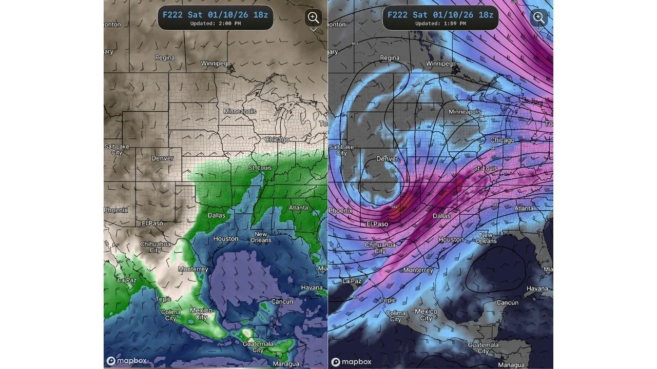
Strong Upper-Level Trough Emerging Across the Southern U.S.
Forecast maps show a deepening trough cutting into the Southwest and Southern Plains, with strong jet-stream support reaching from northern Mexico to Texas, Oklahoma, Arkansas, and the Lower Mississippi Valley.
This pattern is frequently connected with:
- Strong wind shear
- Rapid storm organization
- Potential severe thunderstorms if instability develops
The strongest dynamics appear to be focused from Texas into the central Gulf Coast states, placing many states in a zone that will require close monitoring.
Moisture Return from the Gulf Could Fuel Storm Development
According to model guidance, southerly flow will strengthen off the Gulf of Mexico, allowing precipitation to rush northward into:
- Eastern Texas
- Louisiana
- Mississippi
- Alabama
If this moisture combines with midday heating and the approaching trough, strong to severe thunderstorms may form, posing the risk of damaging winds and heavy rainfall. At this time, particular dangers such as tornadoes and hail cannot be established.
Timing Window: January 8–10 Remains Uncertain
The forecast window is now focused on January 8 through January 10, although meteorologists warn that:
- The system could shift east or west
- Strength could increase or weaken
- Severe weather may fail to materialize if key ingredients do not align
Because the event is still many days away, exact implications are uncertain, and residents should avoid making judgments based on single model runs.
Why Forecasters Are Watching This Closely
Despite the uncertainties, this configuration stands out as one of the first significant severe weather indications of the new year, especially in the southern United States, where winter severe weather is not uncommon.
Combination of:
- A strong trough
- Increasing wind energy
- Gulf moisture return
This system is worth keeping an eye on during the next few days.


