Winter is expected to make a strong return next week, with forecast data indicating the coldest and most dangerous stretch of the season so far for large portions of the Midwest, Great Lakes, and Northeast, as a potential high-impact winter storm looms from the Southern Plains to the East Coast.
Arctic Air Surge Targets the Midwest and Great Lakes
This Article Includes
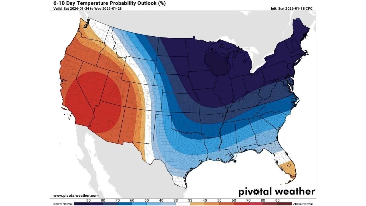
Long-range weather forecasts predict a large swath of well-below-normal temperatures extending across the central and eastern United States from January 24 to 28. Forecasters expect Arctic air to dominate over the Upper Midwest and Great Lakes, where the coldest anomalies are located.


Wind chill estimates are particularly alarming. Wind chills in parts of the northern Midwest could drop to 50 to 60 degrees below zero, posing a concern to anyone exposed to the elements for even brief periods of time. This kind of cold increases the risk of frostbite in minutes and puts enormous strain on infrastructure, heating systems, and livestock.
Cold Push Extends South Into the Plains and Southeast
The Arctic air mass extends beyond the northern tier. Forecasts show the cold spreading southward into the Central Plains, Lower Mississippi Valley, and parts of the Southeast, where temperatures are forecast to be significantly lower than late-January norms.
While wind chills will be less severe than in the Upper Midwest, the cold will still be noticeable in areas unaccustomed to extended freezes. Nighttime lows in the teens and 20s may result in frozen pipes, agricultural problems, and higher heating demand in states ranging from Kansas and Missouri to Tennessee and Georgia.
Major Winter Storm Signal From the Southern Plains to the East Coast
Forecasters are closely monitoring a developing storm system along the southern edge of the Arctic air, which has the potential to absorb Gulf moisture and move northeast. According to model advice, a big winter storm could hit the Southern Plains, the Ohio Valley, and the East Coast.
This configuration creates the possibility of a wide range of impacts, including heavy snow on the cold side of the system and mixed precipitation or rain further south. If the storm connects with the coolest air, heavy snowfall is possible along important transport corridors, notably in the Mid-Atlantic and Northeast.
Why This Pattern Is Concerning
This pattern is particularly disruptive since it combines high cold with the possibility of a large-scale winter storm. Deep Arctic air improves the likelihood of precipitation falling as snow rather than rain, allowing snow to accumulate more efficiently.
Forecasters believe that the current situation could be the most significant winter weather stretch of the season thus far, particularly if the storm route favors densely populated areas along and east of the Mississippi.
What to Watch Over the Coming Days
- Wind chill advisories and warnings likely across the Midwest as Arctic air arrives
- Rising confidence in storm track and precipitation type from the Southern Plains to the East Coast
- Travel disruptions possible late next week if heavy snow materializes
- Energy demand spikes as prolonged cold grips much of the country
Residents in affected regions are being urged to closely follow new forecasts and prepare for both severe cold and probable winter storm impacts as confidence grows.


