Forecasters are now keeping an eye on a potential new snowstorm that might disrupt travel over Valentine’s Day and President’s Day weekend.
According to the National Weather Service, a gradual cooling trend in temperatures will begin on Tuesday, Feb. 10, with Monday, Feb. 9, marking the end of a long stretch of subfreezing highs in the region.
Related posts


Following a long period of dangerously cold weather, temperatures will begin to moderate on Tuesday, Feb. 10.
Temperatures will rise as the cold weather eases. According to AccuWeather, widespread snow cover and frozen ground will hinder the warmer at first, but by mid to late week, some locations will be near or slightly above freezing, then climbing into the 30s and 40s, with near 50 probable in parts of the Midwest and Northeast as snow cover thins.
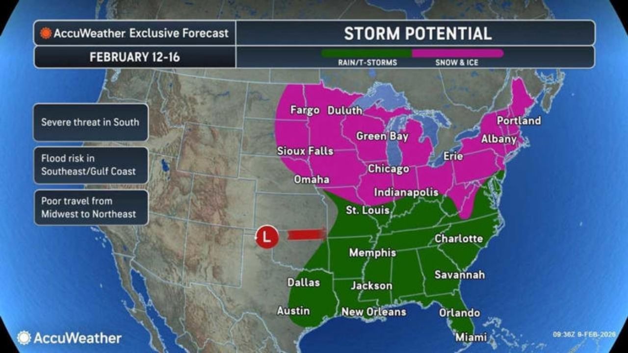
The focus then moves to a possible storm over the long weekend. AccuWeather’s forecast for Thursday, February 12, through Presidents Day on Monday, February 16, shows a broad storm zone from the Plains to the east. The graphics show that snow and ice were more prevalent from the Upper Midwest into the interior Northeast. The graphic also shows bad transit from the Midwest to the Northeast.
The prospective new winter storm is forecast to move from the Midwest to the East Coast during the weekend, including Valentine’s Day on Saturday, February 14, and President’s Day on Monday, February 16.
Several tracks are on the table. A more southerly path would result in heavy rain, flooding, and potentially severe thunderstorms along the Gulf Coast and Southeast. A more northerly trajectory leads to snow and ice accumulation in the Midwest and Northeast.
The preliminary schedule for the Northeast indicates that clouds will increase on Thursday, with precipitation spreading from Friday, February 13, to Saturday, February 14. Interior places may have snow or ice at first, while the I-95 corridor may experience mixed precipitation or rain if the storm moves north. Precipitation may continue into Sunday, February 15, and the Presidents Day holiday on Monday.
Around midweek, the track and rain/snow line will become clearer.


