Saturday, March 14, 2026
  • Terms and conditions
  • Disclaimer
  • DMCA Policy
  • Cookie Policy
RHS News
  • U.S. News
  • Washington News
    • Kennewick News
    • Seattle News
    • Spokane News
    • Tacoma News
    • Vancouver News
    • Yakima News
  • Politics
  • Sports
  • Weather
  • Finance
  • Contact Us
No Result
View All Result
RHS News
Home Weather

Michigan Winter Weather Alert: Lake-Effect Snowfall to Build to 3–6″ Through Monday

by Paige Wuthrich
November 17, 2025
in Weather
Michigan Winter Weather Alert: Lake-Effect Snowfall to Build to 3–6″ Through Monday

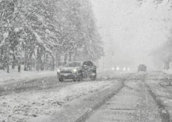
Lake-effect snow showers will strengthen across northern Michigan tonight and continue into Monday morning, posing a risk to travel as high winds combine with short bursts of accumulating snow. According to the National Weather Service in Gaylord, localized snowfall of 3 inches or more is expected, with isolated amounts exceeding 6 inches north of the Mackinac Bridge.

According to the Weather Service, the heaviest snowfall is forecast from late tonight until Monday morning, notably in eastern Upper Michigan near Trout Lake, Whitefish Point, Paradise, and the Soo. Widespread totals of 3-6 inches are expected north of the bridge, with 1-3 inches probable from Gaylord to Grayling and south to Cadillac.

Related posts

This Article Includes

  • 1 Related posts
  • 2 N.Y. Weather Alert: 15 Inches of Snow and 45 MPH Winds to Halt Tug Hill Travel Through Saturday
  • 3 Iowa-Illinois weather alert: More Than 6 inches of snow could strike the Mississippi River corridor by Sunday night.
N.Y. Weather Alert: 15 Inches of Snow and 45 MPH Winds to Halt Tug Hill Travel Through Saturday

N.Y. Weather Alert: 15 Inches of Snow and 45 MPH Winds to Halt Tug Hill Travel Through Saturday

March 13, 2026
Iowa-Illinois weather alert: More Than 6 inches of snow could strike the Mississippi River corridor by Sunday night.

Iowa-Illinois weather alert: More Than 6 inches of snow could strike the Mississippi River corridor by Sunday night.

March 13, 2026

Forecasters say the main danger is not just accumulation but the quick decrease in visibility within stronger bands when winds blow 25 to 40 mph. Blowing snow and crosswinds may make traffic on I-75, M-123, US-2, and M-32 challenging, particularly during the early Sunday and Monday morning commutes.

Localized slick roads, abrupt whiteouts, and shifting snow bands may disrupt travel in northwest lower Michigan, although accumulations are predicted to be light.

Drivers are asked to use caution, particularly in broad regions where blowing snow can quickly obscure roads. Travelers crossing the Mackinac Bridge or heading to the eastern Upper Peninsula should remain vigilant for updates until Monday morning, as conditions can rapidly alter.

ShareTweetPin
Previous Post

YouTube Prankster With 15 Million Followers Taken Into Custody On Drug Charges In Miami

Next Post

Cleveland–Pittsburgh Corridor to Receive 3–12″ of Lake-Effect Snow Through Monday

Paige Wuthrich

Paige Wuthrich

Related Posts

N.Y. Weather Alert: 15 Inches of Snow and 45 MPH Winds to Halt Tug Hill Travel Through Saturday
Weather

N.Y. Weather Alert: 15 Inches of Snow and 45 MPH Winds to Halt Tug Hill Travel Through Saturday

March 13, 2026
Iowa-Illinois weather alert: More Than 6 inches of snow could strike the Mississippi River corridor by Sunday night.
Weather

Iowa-Illinois weather alert: More Than 6 inches of snow could strike the Mississippi River corridor by Sunday night.

March 13, 2026
NWS Warns of Tornado Risk Tonight Across 4 Major U.S. States
Weather

NWS Warns of Tornado Risk Tonight Across 4 Major U.S. States

March 11, 2026
Pennsylvania Weather Alert: Heavy Snow Could Return to Philadelphia & Pittsburgh March 15–21
Weather

Pennsylvania Weather Alert: Heavy Snow Could Return to Philadelphia & Pittsburgh March 15–21

March 10, 2026
Mid-Atlantic Winter Alert: Heavy Snow Could Slam Pennsylvania–New Jersey I-95 Corridor March 15–21
Weather

Mid-Atlantic Winter Alert: Heavy Snow Could Slam Pennsylvania–New Jersey I-95 Corridor March 15–21

March 9, 2026
South Carolina Weather Alert: Snow or Freezing Rain Possible in Columbia and Greenville March 15–21
Weather

South Carolina Weather Alert: Snow or Freezing Rain Possible in Columbia and Greenville March 15–21

March 9, 2026
Next Post
Cleveland–Pittsburgh Corridor to Receive 3–12″ of Lake-Effect Snow Through Monday

Cleveland–Pittsburgh Corridor to Receive 3–12″ of Lake-Effect Snow Through Monday

Leave a Reply Cancel reply

Your email address will not be published. Required fields are marked *

BROWSE BY CATEGORIES

  • Accident
  • Crime
  • Finance
  • Kennewick News
  • Missing Person
  • Politics
  • Tacoma News
  • U.S. News
  • Washington News
  • Weather

Recent News

  • Texas Man Taken Into Custody In Idaho After Alleged Multi-state Credit Card Scheme
  • 2 Dolton Men Charged After Deputies Recover Large Cache Of Drugs And Guns
  • 3 Apprehended After Multi-county Police Chase Ends In Aurora
  • Teens Ran Fentanyl Ring Out Of Suburban Portland Home, Federal Agents Allege
  • South Carolina Couple Sentenced To Prison For Cruel And Deadly Cyberstalking Of Special Needs Victim

Category

  • Accident
  • Crime
  • Finance
  • Kennewick News
  • Missing Person
  • Politics
  • Tacoma News
  • U.S. News
  • Washington News
  • Weather

Important Pages

  • About Us
  • Contact Us
  • Cookie Policy
  • Disclaimer
  • DMCA Policy
  • Editorial Policy
  • Fact-Checking Policy
  • Privacy Policy
  • Terms and conditions
No Result
View All Result
  • U.S. News
  • Washington News
    • Kennewick News
    • Seattle News
    • Spokane News
    • Tacoma News
    • Vancouver News
    • Yakima News
  • Politics
  • Sports
  • Weather
  • Finance
  • Contact Us

© 2025 RhsNews.Co

Go to mobile version